Wellcome to National Portal
মেনু নির্বাচন করুন
Main Comtent Skiped

AT A GLACE MONOHARDI

Monohardi Upazila at a glance


Basic Information:

1.         Boundary                                           :           Monohardi Upazila is bounded by

Pakundia and Katiadi upazilas on the

north,Shibpur upazila on the south, Belabo

and Katiadi upazilas on the east, Kapasia

upazila on the west. Monohardi thana, now   an upazila, was established in 1904.

2.         Geography and area                                     :           Monohardi is located at   / 24.1278°N                                                                                               90.7000°E / 24.1278; 90.7000 and has an area of 193.60 sq                                                                                        km.

3.         Population                                         :           2,84,563

            Male                                                   :           1,39,556

            Female                                               :           1,45,007

4.         Polling Centre                                   :           Parliament -72

                                                                                    Union Porishad-109

                                                                                    Pourasava-9

5.         Voter                                                  :           1,88,832 ( Male 90,779   Female-98,053)

6.         Pourasava                                          :           01

7.         Union Parishad                                 :           12

8.         Village                                               :           172

9.         Rivers                                                 :           04

10.       Mosque                                              :           645

11.       Mandir                                               :           26

12.       Rest house                                         :           01

13.       BTCL                                                  :           01

14.       Sub Post Office                                 :           01

15.       Br. Post Office                                  :           18

16.       Fire Service                                       :           01

17.       L S D                                                  :           04

18.       Helipad                                              :           01

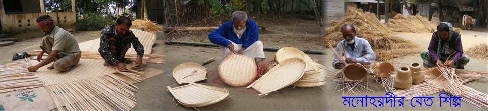
19.       Women handicraft                           :           02

20.       Rice mill (Gov.)                    :                       05

21.       Brick field                                         :           35

22.       Mosque Based Library                    :           04

23.       Sishu Sadan                                       :           01

24.       Auditorium                                        :           01

25.       Community Centre                           :           11

26.       Sub registrar office                          :           01

27.       Cinema hall                                       :           02

02.       ICT

            (1)       Digital Centre                       :           12

            (2)       PISC Centre                           :           01

            (3)       Community E Centre           :           01

            (4)       Computer Lab                       :           10


page-2


page-3

03.       Live stock:

            (1)       Al point                                              :           06

            (2)       Poultry farm                                      :           382

            (3)       Dairy farm                                         :           80

            (4)       Goat farm                                          :           07

            (5)       Sheep farm                                        :           02


04.       Agriculture:

            (1)       Total land                                          :           19,360 hectares.

            (2)       Net cultivable land                         :           15,270 hectares.

            (3)       Net Agricultural land                       :           3714 hectares.

            (4)       Irrigated land                                                :           9,650 hectares..

            (5)       Land Per head                                   :           0.160 acre

            (6)       Per head cultivable land                 :           0.1440 acre

            (7)       Total cropped area                           :           30,960 hectares.

            (8)       Single cropped area                                     :           1120 hectares.

            (9)       Double cropped area                       :           12,610 hectares.

            (10)     Triple cropped area                                     :           1540 hectares.

            (11)     Cropping intensity                           :           202%

            (12)     Total food grain production           :           60,126 metric tons.

            (13)     Food demand                                                :           45,037 metric tons.

            (14)     Surplus food                                     :           15,089 metric tons.

            (15)     Deep tube well                                  :           27

            (16)     Shallow tube well                             :           4013

            (17)     Power pump                                      :           05

            (18)     Agricultural Block                           :           55

            (19)     Agricultural Training Center          :           01

            (20)     Nursery                                              :           10

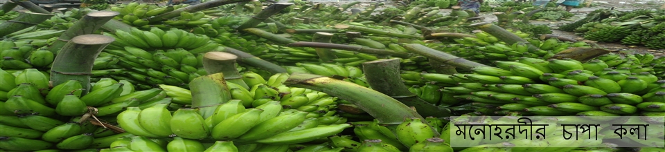
            (21)     Main crops                                        :           Paddy, Banana, Papaya, Jute, betel leaf,                                                                                                          Lemon., sugarcane and jackfruit

            (22)     Agricultural family                          :           53,560

05.       Fisheries:

            (1)       Pond                                                   :           3,229

            (2)       Beel                                                    :           22

            (3)       River                                                  :           122 hectares.

            (4)       Open water bodies                           :           205 hectares.

            (5)       Closed water bodies                        :           347.95 hectares

            (6)       Fish production                                :           2258 metric tons.

(7)       Fish demand                                      :           2910 metric tons.

(8)       Fish deficit.                                       :           652  metric tons.

06.       Co Operative Association:

            (1)       Upazila central co op. association                        :           01

            (2)       Upazila Bittahin central co op. association :       01

            (3)       Union multipurpose co op. association    :           06

            (4)       Multipurpose co op. society                       :           32

            (5)       Artisan co-op society                                  :           01


page-4


            (6)       Saving & credit co-op society                    :           07

            (7)       Mohila Bittahin co-op society                   :           140

            (8)       Mohila co-op society                                  :           31

            (9)       Krishok Samobay Samity                           :           114

            (10)     Ashrayan Multipurpose co-op society     :           02

            (11)     Youth co-op society                                    :           05

            (12)     Special type co-op society                                     :           11


07.       Roads & communication:

            (1)       Roads & Highways Department:  Flexible Pavement (BC) 57 km.

            (2)       Local Government Engineering Department : Flexible Pavement (BC) 324  km,    

                      Brick Pavement : 4.00 km, Earthen : 273 km.(1558 m)

Bridge/Culvert 640 m

            (3)       Zila Parishad : Flexible Pavement (BC) :10 km. Brick Pavement: 8.47 km.


08.       Health.

            (1)       Upazila Health Complex     :           01

            (2)       Community Clinic                :           33 (35 Constructed & 1 Non Constructed)

(3)       Union Sub centre                 :           10 (3 Constructed & 7 Non Constructed)

(4)       EPI Coverage (Sept/13)       :           76%

(5)       Average life Expectancy     :           64     

09.       Family Planning.

            (1)       M.C.H. Unit                           :           01

            (2)       Family welfare centre          :           10

            (3)       Family planning Unit           :           65

            (4)       Total Cupul                           :           55,690

            (5)       C. P.R (Sept/13)                    :           74.17%

10.       D.P.H.E.

            (1)       6 No S t w No (hand T w)    :           2684

            (2)       Tara S t w No      ”                :           740

            (3)       6 No D t w No    ”                 :           313

            (4)       Tara D t w No    ”                  :           38

            (5)       Ring t w No      ”                   :           12

            (6)       Total F. Number                   :           79,450

            (7)       Sanitation      (2005)                        :           100% Coverage.

            (8)       Arsenic Survey Report        :           8.90%  (2003)

11.       Education.


            (1)       College                                   :           08

            (2)       Technical College                :           02

            (3)       Fazil Madrasha                     :           08

            (4)       Alim Madrasha                     :           04

            (5)       High school                           :           42

            (6)       Girls High school                 :           09

            (7)       Dakhil Madrasha                  :           13

            (8)       Junior High school               :           05

            (9)       Junior girls’ High school    :           02


page-5

12.         Primary education

            (1)        Govt. Primary school                          :           143

            (2)        Registered  Non govt. Primary school  :           31

            (3)        Community Primary school                :           05

            (4)        Ebtadae Madrasha                              :           5

            (5)        Rate of child attendance                     :           87.8%

            (6)        Rate of child admission                      :           99.87%

            (7)        percentage of Literacy                                    :           49.9%


13.       Land Management:

            (1)        Union Land office                              :           11

            (2)        Mouja                                                  :           128

            (3)        Govt. Property                                                :           1045.14 acres.

            (4)        Nen cultivable land                             :           3714 hectares

            (5)        Non Agricultural land             :           4090 hectares.

            (6)        Vested Property                      :           1160.282 acres.

            (7)        Leased Property (Ka)              :           242.8245 acres.

            (8)        Non Leased Property (Kha)    :           917.4565 acres

            (8)        Hat Bazar                                :           23

            (09)      Govt. pond                              :           10

            (10)      Closed water bodies               :           10

            (11)      Jackfruit Mahal                       :           4

(12)      Adarsha Gram                         :           01

            (13)      Family of Adarsha Gram        :           13

            (14)      Asrayan project                       :           1 (Bogadi, rehabilitated family 10)

            (15)      Abasan project                        :           1 (Rampur,  rehabilitated family 40)


14.       Bank:

            (1)        Sonali bank                             :           02

            (2)        Bangladesh Krishi bank          :           04

            (3)        Agrani bank                            :           02

            (4)        Janata bank                             :           02

            (5)        Grameen bank                         :           04

            (6)        Brac bank                                :           01

            (7)        Dutch Bangla Bank                :           01

            (8)        Karmashangsthan Bank          :           01


15.       N.G.O.                                                :           10


16.       Distance of Union and Zila Sadar from Upazila :


            (1)        Lebutala                                  :           08  km.

            (2)        Chalakchar                              :           06  km.

            (3)        Chandanbari                            :           02  km.

            (4)        Khidirpur                                :           14 km.

            (5)        Charmandalia                          :           17 km.

            (6)        Barachapa                               :           13 km.

            (7)        Kachikata                                :           09  km.

            (8)        Shukundi                                 :           3  km.

            (9)        Daulatpur                                :           10 km.

            (10)      Ekduaria                                  :           05  km.

            (11)      Gotasia                                    :           10 km.

            (12)      Krisnapur                                :           16 km.

            (13)      Zila Sadar                                :           28 km